Island Stories:
![]() Danzig
Mine
Danzig
Mine
![]() Zeballos
Iron Mine
Zeballos
Iron Mine
![]() Conuma
Peak 1910
Conuma
Peak 1910
Alexandra Peak
Argus Mountain
Bate/Alava Sanctuary
Beaufort Range
Big Interior Mtn
Big Interior Mtn 1913
Part 1
Part 2
Bolton Expedition 1896
Cliffe Glacier
Clinton Wood
Comox Glacier
Comox Glacier 1922
Comox Glacier 1925
Comstock Mtn
Conuma Peak
Copper King Mine
Crown Mtn
Elkhorn 1912
Elkhorn 1949
Elkhorn 1968
Eugene Croteau
Golden Bullets
Golden Hinde 1913/14
Golden Hinde 1937
Golden Hinde 1983
Harry Winstone Tragedy
Jack Mitchell
Jim Mitchell Tragedy
John Buttle
Judges Route
Koksilah's Silver Mine
Landslide Lake
Mackenzie Range
Malaspina Peak
Mariner Mtn
Marjories Load
Matchlee Mountain
Mount McQuillan
Mt. Albert Edward
Mt. Albert Edward 1927
Mt. Albert Edward 1938
Mt. Becher
Mt. Benson 1913
Mt. Benson
Mt. Doogie Dowler
Mt. Colonel Foster
Mt. Hayes/Thistle Claim
Mt. Maxwell
Mt. Sicker
Mt. Tzouhalem
Mt. Whymper
Muqin/Brooks Peninsula
Nine Peaks
Queneesh
Ralph Rosseau 1947
Rosseau Chalet
Ralph Rosseau Tragedy
Rambler Peak
Red Pillar
Rex Gibson Tragedy
Sid's Cabin
Steamboat Mtn
Strathcona Park 1980's
The Misthorns
The Unwild Side
Victoria Peak
Waterloo Mountain 1865
Wheaton Hut/Marble Meadows
William DeVoe
Woss Lake
You Creek Mine
Zeballos Peak
Other Stories:
Sierra
de los Tuxtlas
Antarctica
Cerro del Tepozteco
Citlaltepetl
Huascaran
Mt. Roraima
Nevada Alpamayo
Nevada del Tolima
Nevado de Toluca
Pico Bolivar
Popocatepetl
Uluru/Ayers Rock
Volcan Purace
Volcan San Jose
Biographies
Island 6000
Cartoons
Order the Book
Contact Me
Links

Mount
Hayes:
And the old Thistle Claim
by Lindsay Elms
About five kilometres northwest of the town of Ladysmith is the rounded summit of Mount Hayes. Logging roads circumvent the mountain and clear-cuts are the dominant feature scarring the landscape. One kilometre west of the mountain FortisBC Energy, Inc., formerly known as Terasen Gas, has constructed a storage facility that holds 1.5 billion cubic feet of Liquified Natural Gas which was completed in 2011 and can be seen from the summit, however, the surrounding views are not very exciting as the mountain is under 600 metres in elevation. Fortunately, of historical interest is the old Thistle claim located 1.5 kilometres northeast of the summit of Mount Hayes which dates back to 1904.
The following description of the site and mineral composition of the Thistle claim is from the Ministry of Energy Minfile No. 092GSW020:
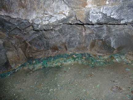
The showing consists of a mineralized vein, traceable over 31 metres and from 5 to 305 wide hosted in granodiorite. The vein is coarsely crystalline, composed mainly of quartz irregularly intergrown with feldspar and minor mica. The vein is reported to to host up to 10 per cent chalcopyrite, bornite and molybdenite make up perhaps 10% of the vein matter. Development consists of two short adits, one 8 metres above the other, connected by a short inclined level and a stope. [A stope is the open space left behind after the removal of the wanted ore from an underground mine.] This work, done by the Vancouver Exploration and Development Company in 1904-05, showed the vein to be too small and too low grade to be of economic importance.
The showing was restaked in 1939-40 as the Duff and Good Strike mineral claim, registered in the name of H.C. Duffus. In 1942 these were leased to the Ladysmith Copper Syndicate, but apparently no further development work was carried out.
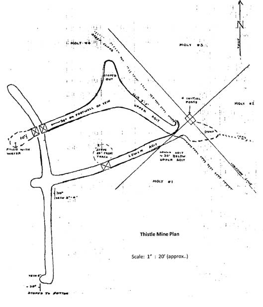 |
In the 1963 Minister of Mines Report, four claims on Mount Hayes were owned by F.W. Wilson and M. Keeble and called "Molly" #1-4 (former Thistle claim). By the end of the 1965 season, H. Laanela wrote a report on the Mount Hayes Copper Showing which was published in February 1966 and printed below:
Adits are located on steep cliff facing northerly north of Mt. Hayes, south of an old logging road (washed out culverts) from Ladysmith to Halsam Creek. Access via a road just south of Cassidy airport on main highway.
Country rock is altered, in place gabbroic, diorite, with some andesite volcanic rocks (Sicker group) nearby. This diorite stock forms the mass of Mt. Hayes; around its margins much dark, coarse gabbroic rock can be found; near summit it consists of hybridized and mixed intrusive with cherty sediments. There seem to be sets of long SE-NW trending faults in Nanaimo sediments on either side of the intrusive body.
On dump outside the lower adit some quite rich looking massive bornite, with chalcopyrite and molybdenite in quartz matrix was seen. Some copper stain was seen on cliff above adit, but no vein was seen.
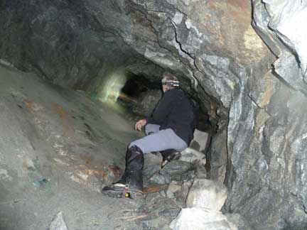
Later it was revisited with T.F. Schorn, the lower adit was entered and the upper adit, directly above the lower one, was entered by crawling up a stope. A sketch map was made of the workings. The vein, which the workings follow, was very good grade of massive ore, but rather narrow, averaging 2-6 inches in workings, and seemingly pinching out to almost nothing in most cases. In the end of southerly cross-cut in lower adit it is still 6 inches wide in the bottom of a shallow stope, general dip of vein is 30? or less westerly, into the mountain side. Another shallow stope was filled with water. Stoped out part of the workings follows the vein into the upper adit.
Four I.F. claim posts were in front of adits: staked on July 3 and 4, 1964 by C. Klemm, with location line running NW-SE along the base of the cliff. Adit is apparently in "Molly" #4 claim, driven WSW.
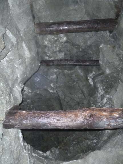
An obscure blazed trail, hard to follow, was found on road below, leading to showing 530' above the road in elevation. Adits are in good shape, no timbering. Parts of the old rails are still found in adit. An old steam-boiler was seen below the adit and remnants of old corduroy-road, all possibly 50-60 years old.
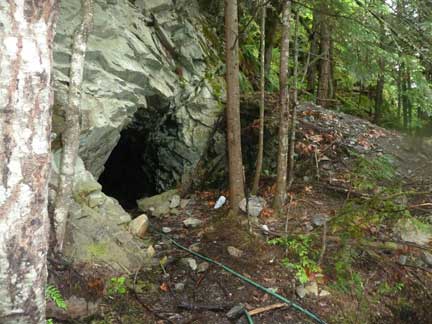
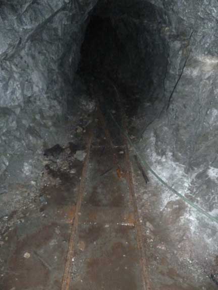
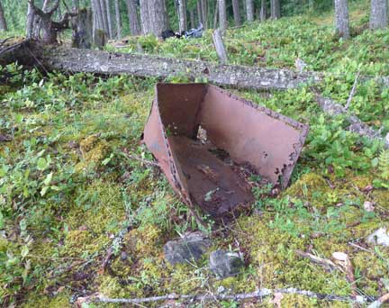
Today, the Thistle claim, which comprises of two adits, can be reached from the end of a logging road by a short trail which climbs steeply up to the lower portal. Old rail tracks can still be seen on the floor of the lower adit and veins of copper are easily recognized on the walls. At the water-filled stope at the end of one on the adits branches, another steep stope angles up to the upper adit, but it is very slippery. The upper adit can be reached from the outside by the use of a rope up the steep rock wall from the lower adit. Outside the lower entrance is the dump where rock from the claim was emptied out by the ore carts. By sifting through the rock interesting specimens can be found by rock hounds and lower down the slope in a clearing in the forest are the remains of where a cabin once stood and an old ore cart.
|
Entrance to Thistle claim |
Water filled stope |
|
|
Railway tracks in lower adit |
Wooden bracing |
|
|
Copper vein |
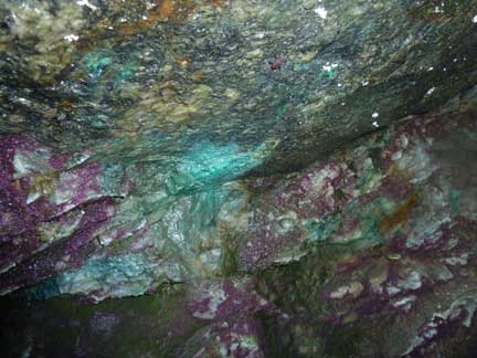
Mineral display in adit |
|
|
Stope leading to upper adit |
Old Mine Cart |
How to order | | About the Author || Links || Home
Contact:
Copyright ©
Lindsay Elms 2001. All Rights Reserved.
URL: http://www.beyondnootka.com
http://www.lindsayelms.ca