Island Stories:
![]() Danzig
Mine
Danzig
Mine
![]() Zeballos
Iron Mine
Zeballos
Iron Mine
![]() Conuma
Peak 1910
Conuma
Peak 1910
Alexandra Peak
Argus Mountain
Bate/Alava Sanctuary
Beaufort Range
Big Interior Mtn
Big Interior Mtn 1913
Part 1
Part 2
Bolton Expedition 1896
Cliffe Glacier
Clinton Wood
Comox Glacier
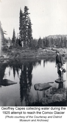
Comox Glacier 1922
Comox Glacier 1925
Comstock Mtn
Conuma Peak
Copper King Mine
Crown Mtn
Elkhorn 1912
Elkhorn 1949
Elkhorn 1968
Eugene Croteau
Golden Bullets
Golden Hinde 1913/14
Golden Hinde 1937
Golden Hinde 1983
Harry Winstone Tragedy
Jack Mitchell
Jim Mitchell Tragedy
John Buttle
Judges Route
Koksilah's Silver Mine
Landslide Lake
Mackenzie Range
Malaspina Peak
Mariner Mtn
Marjories Load
Matchlee Mountain
Mount McQuillan
Mt. Albert Edward
Mt. Albert Edward 1927
Mt. Albert Edward 1938
Mt. Becher
Mt. Benson 1913
Mt. Benson
Mt. Doogie Dowler
Mt. Colonel Foster
Mt. Hayes/Thistle Claim
Mt. Maxwell
Mt. Sicker
Mt. Tzouhalem
Mt. Whymper
Muqin/Brooks Peninsula
Nine Peaks
Queneesh
Ralph Rosseau 1947
Rosseau Chalet
Ralph Rosseau Tragedy
Rambler Peak
Red Pillar
Rex Gibson Tragedy
Sid's Cabin
Steamboat Mtn
Strathcona Park 1980's
The Misthorns
The Unwild Side
Victoria Peak
Waterloo Mountain 1865
Wheaton Hut/Marble Meadows
William DeVoe
Woss Lake
You Creek Mine
Zeballos Peak
Other Stories:
Sierra
de los Tuxtlas
Antarctica
Cerro del Tepozteco
Citlaltepetl
Huascaran
Mt. Roraima
Nevada Alpamayo
Nevada del Tolima
Nevado de Toluca
Pico Bolivar
Popocatepetl
Uluru/Ayers Rock
Volcan Purace
Volcan San Jose
Biographies
Island 6000
Cartoons
Order the Book
Contact Me
Links

Comox
Glacier 1925:
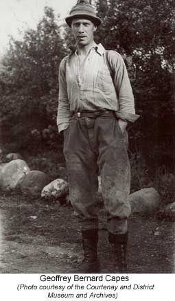
Capes and Paul's Unsuccessful First Attempt
From
The Comox Argus August 13, 1925.
The Glacier
Interesting Trip to Foot of Comox Mountain
More and more interest is being taken in the country back of the strip of littoral, which forms the inhabited part of Vancouver Island; that expanse of valley and mountain, unknown save to the trapper and the prospector. Last week Messers G. [Geoffrey] B. Capes and W.A. [Adrian] B. Paul made a traverse into country at the foot of the Comox Glacier; and Mr. C. [Clinton] S. Wood explored the country at the source of the Brown's River. Both found wonderful country. Below is a graphic description of the trip to the glacier country.
"Leaving Comox Lake about 11.50 we followed the trail on the south side of the Cruikshank River; it was very good in parts, winding through timber and lined with bushes of luscious looking huckleberries and blueberries. There were two little bluffs, the crossing of which gave us an inkling of what was to come. We had been walking about an hour when the trail disappeared in a pleasant, shady tangle of Devil's Club and salmon berry, but mostly Devil's club. The thorny limbs of the Devil's Club were thick, and the large thorny leaves sought the light high above our heads. There was no help for it, we struggled to the river bank, to find the water too deep for wading; we crawled on our hands and knees; we chopped at branches; we walked hopefully through any opening, usually to find the way blocked; and finally zigzagged into better country.
 The
Trail and Devil's Club
The
Trail and Devil's Club
Thereafter, being wiser, we waded the river, walking the shingle bars,
and taking to the woods when convenient. In two hours we reached the south
fork, along the east bank of which we turned. As the going was bad, we
took to the stream, and later crossed to the other side, where after a
time we struck a trail. One set of the blazes were thick with age, a second
set had the appearance of not being more than a year old. We followed
this trail, which wound around the base of the mountain; crossing every
now and again, some dry creek bed full of boulders.
We noted with interest the good judgment of the gentlemen who had blazed the trail; they had done anything to avoid Devil's Club, preferring a steep hard climb to going through it. After several miles the trail climbed steeply, then descended to the creek, where we lost it in the brush. After some deliberation we mounted the slope again, and continued in a South Westerly direction; the steep mountain sloping up on the one side, and down below the noisy little creek.
In choosing our direction we hoped for the best, as we were in a valley, we had little choice, unless we climbed the mountain. Our vision was limited by the trees, and down below the greener foliage which marked the course of the creek. About seven we descended to the creek, at a point where it forked; and pushing through the brush, followed the branch going westerly. At 7.30 we flung down our packs on a large island of shingle.
An hour was spent cutting boughs and making camp; after a supper of bacon and eggs and much tea we sought our blankets.
Climbing With Packs
The following morning, after some discussion as to the direction we should
take, we started about 7.45 in a north westerly direction up the mountain
side; and soon discovered that climbing with packs on our backs was not
quite as easy as going along the level. The way was steep, but the footing
good, and we had no difficulty for two thousand feet, when as series of
bluffs barred our way. By this time our clothes were soaked through in
perspiration and we were wondering about the chances of water on top.
A way was found up the bluffs and the angle of the climb became less acute;
but by this time we stopped more often for a short rest. Not far from
the top a glimpse through the now thinner timber of a high snow topped
mountain informed us we had missed our goal.
Though we had set out with an objective, the fact that we did not know if we could climb the objective when we got there, and that we were seeing a new country, and that in any case the sun was shinning and the forest and mountains were there for our benefit, did not permit us to be downcast. What could not be done on this trip could be done at another time. So we forced our weary legs to carry us and our packs ever upwards.
Long ago we had left the Devil's Club and the red huckleberry. Small blueberries grew on scrubby bushes. There was less timber, and the trees were smaller, some pine and yellow cedar.
The Gleaming Glacier
The slope grew easier, the top seemed nearer, but ever as we climbed a
bluff, another appeared a little higher; but at last after three or four
hours of climbing, we emerged on the top; and the first or perhaps the
second sight that greeted us, was the gleaming glacier, towering above
us; the other was a little lake nestling in a hollow. The latter was more
important for the moment as our one fear had been that we might have to
descend for water.
A more or less flat mountain top lay before us, the surface covered with rock, flat rock easy to walk on; buttresses of rock; steps and terraces of rock; the soil between the rock was peat mostly covered with heather. The timber was small and scattered, and appearing between the trees and above, the snow covered summit of the Dome, known so well in Courtenay as the Glacier.
Dotting the surface here and there, were ponds and little lakes, small bushes growing round the sides of some; others bounded by rock walls; some clear, others covered with water lilies. By the side of one of these, in a little dip in the peaty ground we flung down our packs; although only half the day was gone, we decided to camp in this spot for the night.
A Bird's Eye View
After a meal, during which we drank much tea, we wandered over our mountain,
as we called it. First we made for the corner, from which in one direction,
we looked down on Comox Lake, and beyond where Comox Valley was hidden
in its veil of smoke from bush fires. In every direction a panorama of
mountains; we could mark the valley of the Cruikshank, and the creek up
which we had traveled. In a few minutes we knew more about the lay of
the land than we had learnt in the years we had lived in the district.
Having gazed, compared the country with the map, taken bearings with the compasses, we turned away and strolled towards a ridge much higher than we were. After the limited view of wooded valley, it was a great relief to be able to walk in comfort. We reached a spot were we climbed down on to a rocky perch, and before us across a deep valley, was the whole face of the glacier. From the round Dome, the snow formed a kind of semi-circle, ending in an ice cliff, the face of which might be anything from 100 to 300 feet thick.
The Dome
The ice cliff was not smooth, but eaten into, giving one somewhat the
impression of a huge mouth, with about half its complement of teeth; near
the edge of the snow on the surface, the smoothness was broken, as if
huge chunks of ice and snow were about to break off and slide into the
depths below. From the bas e of the ice cliff, numerous little threads
of water ran down the almost perpendicular mountain side, dropping every
now and then into space, and striking the mountain again, until at the
bottom it ran off in many little creeks.
We observed the creek on which we had camped, winding its way up the valley, and ending in a big patch of dirty looking snow, some two thousand feet or so below the summit of the glacier. We studied this point with more care, wondering could we have climbed the glacier had we followed the creek. To the right a rocky slope ended in the snow; it looked possible but doubtful; one thought of what would happen should a slip be made. A little to the left was what appeared to be a three sided chimney; this also looked possible; once climbed we would be on a snowy slope leading to a kind of connecting mountain between the Glacier and another but smaller mountain. This snowy gap bore two trees wide apart.
To the left of the chimney there was a mountain bridge, joining the main mountain at the top of the chimney, the end the nearest to us curving down very steeply; next to this again was a mountain forming one side of the creek. We thought it possible, one might find a way between the bridge and the mountain to reach the two tree gap, from which it seemed as if one would be sure to reach the Glacier summit.
Gay With Flowers
Leaving this comfortable observation point, we dipped down over rocky
terraces, into a small valley, across which rose the ridge we had been
making for; our mountain and the ridge made a rough "L." A small
creek led downwards but the water in it could be reckoned by drops. On
this sheltered slope the vegetation was thick and luxuriant; open glades,
looking fresh and green, were studded with purple and yellow daisies,
and surrounded with what we took to be rhododendron bushes, with small
cream colored blossoms.
Returning to camp we enjoyed a bathe in the warm water of the little lake, after supper we went back to the observation point overlooking the Comox Valley; but the smoke haze was thicker than before. The only new discovery we made was a small lake, probably the source of the South Fork of the Cruikshank.
Up at that height we expected to spend a cold night, but it was not bad, a little chilly in the early morning hours. After a leisurely breakfast and a swim, we hoped to have a better view of the Comox Valley, nut except for the topmost peaks of the Coast Range, standing above the smoke, we saw nothing new. On our way we surprised a buck standing in full view upon a rock.
Two caves in Glacier
Returning, putting on our packs, we paid a last visit to our view point
of the Glacier; the early morning sun being at our backs, we had a better
view of it than the day before; we noticed the square openings of two
inaccessible caves in the mountainside.
From there, we dipped into the valley and at the highest point of it, we dropped our packs, and in twenty minutes had climbed to the top of the ridge. Another view opened before our eyes; in one direction Comox Lake; in another innumerable mountains and valleys. Northwards towards Mount Washington, lay a long flat mountain along the summit of which, one could probably walk for eight miles on level ground. Below us lay a lake of some sixty acres in extent, the outlet of which looked to us to take a tremendous drop, almost at the edge of the lake.
White and Purple Heather
The ridge we were on must have been about three miles long; a series of
little mountains and little valleys; on the open mountain tops between
the rock, the soil was covered with heather, both white and purple; the
valleys were covered in bush and small trees; we followed the ridge alternately
climbing and descending; some of the climbs quite steep; the little valleys
were knife edged; on one side looked down upon the lake, on the other
into the depths of a far deeper valley. After some three hours travelling
we reached a pinnacle, from where we could not have been more than half
a mile from the Glacier; at our first viewpoint the water tumbling down
the mountain had looked like threads of ice; now we could see the actual
movement of the water.
The Deep Abyss
Bending over, one looked down some thousand or fifteen hundred feet into
space; an open slope lay below where snow still nestled in the shady spots.
Between our ridge and the Glacier lay a steep mountain, looking as if
broken off at one time from the ridge. To the right a long valley opened
out. On our return we crossed three patches of snow, the only snow we
touched on our trip; although below us there was plenty.
It was nearly four o'clock when we reached our packs; we had a little difficulty finding a place to build a fire, the soil being dry and peaty; after a meal about 4.45 we began our homeward journey. Our intention was to follow the creek down; for a short distance all went well; then we came to a drop, impossible to descend, so we clambered p the mountain side and came back to the creek later; there was thick brush on the mountain, which while it gave us something to hold onto, made the travelling difficult. Several times we had to leave the creek in this way, until at last it ran through a narrow canyon, at the entrance of which it dropped sheer some sixty feet. Thereafter we kept to the mountain side.
 New
Kind of Thistle
New
Kind of Thistle
The way was very steep, and the inclination was to keep mounting when
we wanted to go down; the easier routes always seemed to lead upward.
The long limbs of the vine maple, and sometimes long cedar branches, enabled
us to cross places which otherwise would have been dangerous to attempt.
Occasionally a spot would be reached where there was nothing to hold on
to, and down below a steep smooth slope, ending most likely at the edge
of a precipice; but these places had to be crossed. Usually at these times
the packs had a habit of asserting themselves; we were both carrying things
in our hands; one, the billycan; the other, the axe and a flour sack containing
plants, which we called Flora. Three times the billycan clattered down
the slope, but retrieved none the worse except for some small dints. In
one of the most difficult spots we observed a form of thistle new to us.
Deer Make Good Trails
After some hours of travel we discovered that any well worn deer trail
proved an excellent guide; we found that we could go anywhere the deer
went; and any place they avoided we could not pass; sometimes we would
lose a tail but always fond another. Often we reached an impasse, and
had to scramble back, climb higher and try again elsewhere. Dusk was on,
our destination appeared close, the noise of the main creek reached us;
and even some straggling Devil's Club grew here and there; we were becoming
hopeful. We arrived once more on the creek, walked a short distance, stopped,
and gazed some three hundred feet into space; as far as we could see on
either hand, there was no chance of descending. It was a quarter to eight,
so we climbed back into the timber, flung down our packs, then had supper
on a rock in the middle of the creek. We had not much energy left, after
travelling ten hours.
Difficult Going
The next morning we started northwards along the mountain side, and after
seeking in vain for a place to descend, with some difficulty we retraced
our steps, crossed the creek, and struck a deer trail which led us to
the top of a bluff; the descent from there looked possible although not
easy; so after casting about we found a safe way round the end of a huge
boulder, and on to a rock slide covered with fallen timber; we scrambled
down without trouble and finally found ourselves on the trail we had followed
on our way in.
The trail eventually disappeared among some Devil's Club; so crossing the creek we climbed a little way into the timber, where for some time we had good going, until the way became too steep, forcing us through a jungle of brush, through a swampy place, back on to the creek. After this we waded the creek, walking the shingle bars, or taking to the woods as suited best. We at last reached the Cruikshank River.
After a rest and a meal,
we crossed the river, and found a trail on the north side, which we followed
until it stopped at a shingle bar; having by this time passed the bad
patch of Devil's Club on the south side of the river, we crossed over
on a log and struck the trail which brought us out again at the starting
point on Comox Lake.
How to order | | About the Author || Links || Home
Contact:
Copyright ©
Lindsay Elms 2001. All Rights Reserved.
URL: http://www.beyondnootka.com
http://www.lindsayelms.ca